T2GIS delivers GIS consulting, custom mapping solutions, and court-ready wildfire analysis backed by 20+ years of expertise across municipal, utility, mining, and legal sectors.
From wildfire litigation support to municipal asset tracking, we build the spatial infrastructure that powers better decisions.
Pre-fire and post-fire property evaluations with burn severity mapping, satellite imagery overlays, and court-ready PDF reports for litigation support.
Full-service geospatial consulting within the ESRI ecosystem. We design, build, and maintain spatial databases and mapping workflows.
Mobile-ready inventory management for municipalities and utility companies. Track infrastructure, manage field data, and train your teams.
Deploy mobile data collection workflows with real-time sync. We train your field crews and support ongoing operations with regular meetings.
Purpose-built geodatabases that scale with your needs. From SpatiaLite to enterprise SQL Server — the right solution for your data volume.
Detailed mapping for large-scale projects including mine expansion, pipeline routing, and environmental monitoring with multi-stakeholder coordination.
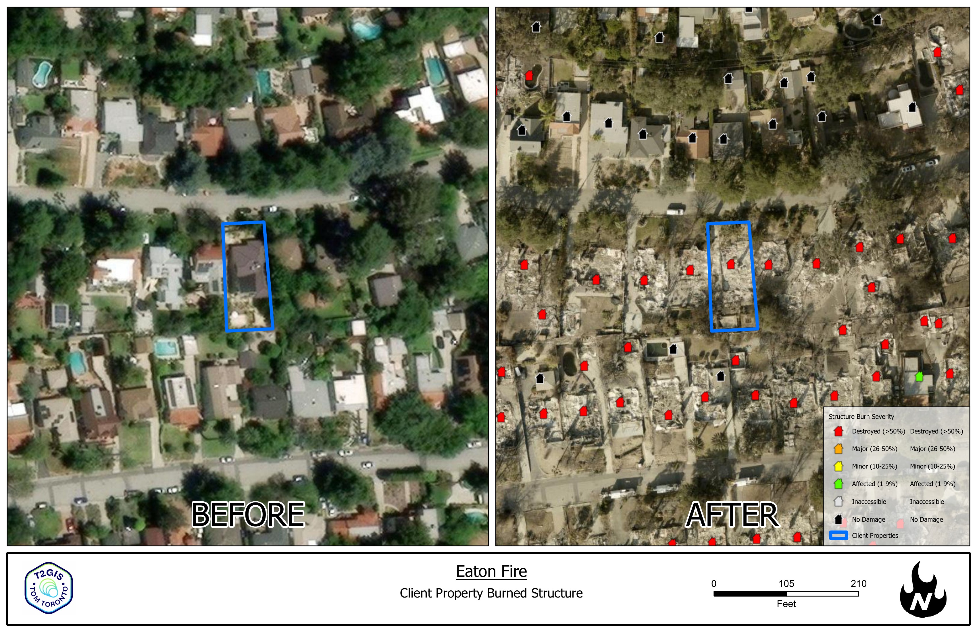
Generate professional before & after burn damage reports for any property in the fire perimeter. Built for attorneys handling wildfire litigation.
Enter any address within a California wildfire perimeter. Our system locates the parcel, pulls high-resolution satellite imagery from before and after the fire, and generates a professional PDF with burn severity analysis.
T2GIS is a Utah-based geospatial consulting firm well-established in the GIS community across state, county, and city government. Our team brings decades of hands-on experience delivering practical GIS solutions — from municipal utility tracking to high-stakes wildfire litigation support.
We serve smaller cities and utility companies that need dedicated GIS expertise without a full-time hire, as well as large-scale operations like Rio Tinto/Kennecott Copper where we manage infrastructure mapping and mobile field data collection for multi-hundred-million-dollar expansion projects.
Whether you need wildfire damage reports or a full GIS implementation, we'd love to hear from you.
Reach out and we'll get back to you within 24 hours. For urgent wildfire analysis needs, mention it in your message and we'll prioritize your request.